The Grand Valley Fluvial Hazard Zone Map
This map is for additional information only
The Fluvial Hazard Zone (FHZ) is the area a stream has occupied in recent history, may occupy, or may physically influence as it stores and transports water, sediment, and debris. The FHZ has been mapped for most of the Colorado and Gunnison Rivers in Mesa County as part of the Colorado Water Conservation Board’s Fluvial Hazard Zone Program.
What is a Fluvial Hazard Zone?
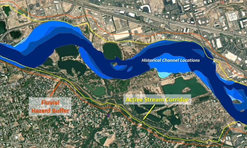
As defined above, the FHZ delineates the boundaries within which a stream or river could move or physically influence either gradually over time or as a result of a large flood event. The Active Stream Corridor, shown in yellow below, defines the corridor within which the Colorado and Gunnison Rivers would migrate over time without the influence of development or infrastructure in the floodplain. This is the corridor where dynamic river processes, such as bank erosion and deposition, will occur.
The Fluvial Hazard Buffer, shown in red below, is the margin that extends into hillslopes and other areas that bracket the Active Stream Corridor. This zone, often thought of as being “high and dry” could still be vulnerable to erosion and hillslope failure resulting from a dynamic river. Its width is influenced by the local geology and proximity to the active channel. Other components of the FHZ are described here.
This video provides an introduction to the Fluvial Hazard Zone and program
Is the Fluvial Hazard Zone regulated?
At this time, there are no regulations or zoning associated with the FHZ in Mesa County. Unlike the FEMA Flood Insurance Rate Maps (FIRMs) produced and regulated as part of the National Flood Insurance Program and managed by local governments, the FHZ maps are not currently associated with floodplain permitting or regulations in Mesa County. The FHZ map, like other geologic hazard maps, is provided for public information only.
My property is in the Fluvial Hazard Zone. What does this mean?
The FHZ map delineates the corridor around a river that is subject to river processes of flooding, migration of the channel through bank erosion and deposition in islands and bars, transport and deposition of woody material, river channel erosion of hillslopes, and new channel formation, among other river processes. If your property is within the FHZ, this indicates that it may at some point experience these processes. Note that the FHZ does not quantify a probability or time frame.
The FHZ should be interpreted at a 1:25,000 scale and should be used for parcel level considerations rather than site scale (where to site specific footprints or infrastructure). A more detailed geohazard or geotechnical analysis is required for site-scale development and design.