Ute Meridian (Re-survey guidelines)
What are the guidelines for Resurvey?
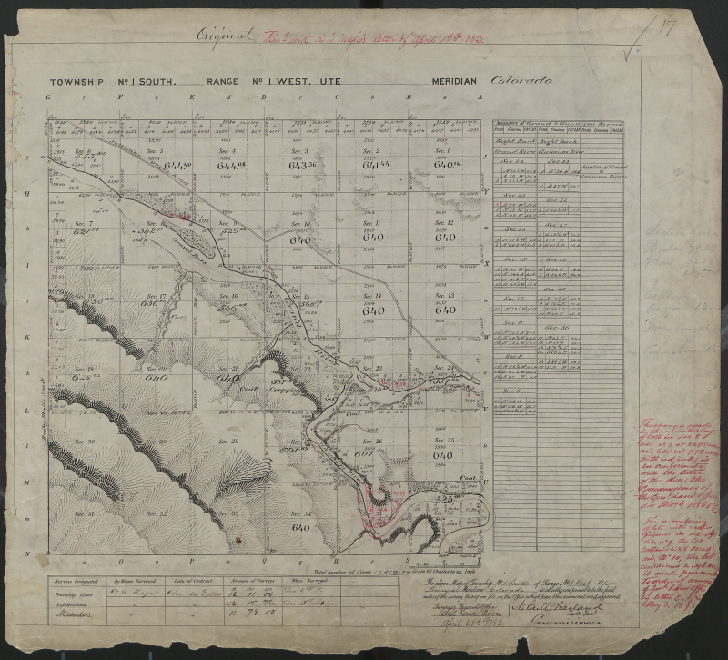
Mesa County, located at the confluence of the Grand (Colorado) and Gunnison Rivers on the Western Slope, is a very unique area for land surveying. The original GLO surveys are based on three meridians: 6th Principal Meridian, New Mexico Principal Meridian and the Ute Meridian. Therefore, it is very important to know and understand which method of surveying is required for any given township in the county. Townships based on the 6th and New Mexico meridians, use the standard BLM section retracement and breakdown methods. Surveying in the Ute meridian however, is unique, and very different from a standard section retracement or breakdown; and adhering to the 3-Mile Method is required.
Basically the Ute Meridian covers the Grand Valley from the east end in Palisade to the west end of Mack through Grand Junction, Fruita, and Loma. It also covers the area south of Grand Junction to Whitewater. The Ute Meridian was established in 1880 to provide 40 acre tracts for the Uncompahgre Utes. The survey had to be done quickly in order to lay out a reservation for the Indians. For this purpose the Special Instruction, sent out by the Department of the Interior, General Land Office (The Three Mile Method), created a very different type of section. However, once the reservation was established the decision was made to move the Indians to another location. Therefore, the area was never used as a reservation. The Three Mile Method, however, turned out to be very good for creating 40 acre tracts for agriculture and farming in the Valley; and for establishing a network of control, which included all of the 1/16 corners of each section.
Resurvey Guidelines
Ute Meridian Resurvey Guidelines